| Les grands travaux du 19ème siècle et, en premier lieu, la construction du pont et de ses accès ont transformé le paysage rochois, mais aussi la route de Redon au Croisic achevée en 1847. En effet, la municipalité ayant refusé le raccordement au chemin de Guérande par le Rodoir, c’est la descente de la rue St-James qu’il fallut prolonger par une rampe en lacets détruisant une vingtaine de maisonnettes sur la pointe du Ruicard. Le passage malaisé conduisit en 1856 au dessin d’un plan d’alignement. La maison du canon fut épargnée par cette contagion Haussmannienne au détriment des maisons qui encombraient ce virage. Cela nous valut un |
The “PLACE DU PILORI”
Major building works of the 19th century, the construction of the bridge and the construction of the road from Redon to Le Croisic in 1847, transformed the topography of the town. Because the Municipality had refused to link the new road via the Rodoir, the Rue St. James had to be extended causing the destruction of some 20 small houses in the old Quarter. The Maison du Canon (the Mairie) escaped this redevelopment. An elegant art nouveau house in limestone also remains, but it would have replaced a timber- framed one. |
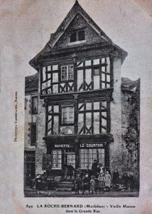
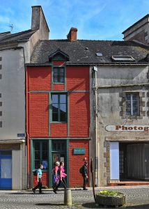
carte postale ancienne vers 1905-1910 avant Vue prise en 2018
la démolition de la maison à colombages